Cyclone Alfred - Australia
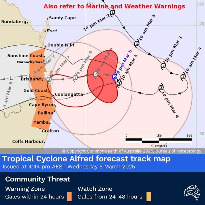
Tropical Cyclone Alfred, a category 2 system, is 325km east of Brisbane and 305km east-north-east of the Gold Coast.
Alfred is moving towards the south-east Queensland coast, with the far western edge beginning to reach the coast from about Coolangatta to Ballina.
Alfred is forecast to maintain category 2 intensity as it approaches the south-east Queensland coast this afternoon and tomorrow. The centre of Alfred is expected to cross the coast early Friday morning, most likely between Maroochydore and Coolangatta.
Gales with damaging wind gusts to 120km/hr are developing near the coast from Coolangatta to Ballina and are expected to develop along the remaining south-east Queensland and north-eastern New South Wales coastal and island communities between Double Island Point and Grafton from later today and persist on Thursday and Friday.
Destructive wind gusts of up to 155km/hr may develop about coastal and island locations near and to the south of the track, possibly as far south as about Cape Byron, from Thursday afternoon as Alfred's destructive core approaches and crosses the coast.
A dangerous storm tide may occur along the coastal foreshore, particularly in areas near and south of the cyclone centre, possible as far south as Cape Byron, if the time of coastal crossing coincides with the high tide early Friday morning.
Tides are likely to rise significantly above the highest high tide mark with damaging waves and dangerous inundation of coastal low-lying areas.
Abnormally high tides are likely to continue causing minor flooding of coastal low lying areas between Double Island Point and Grafton, particularly during the time of high tides Wednesday night into early Thursday morning and Thursday night into early Friday morning.
Damaging surf leading to significant beach erosion remains likely for the open beaches between Double Island Point and Grafton, and further south over the New South Wales coast. Separate Coastal Hazard and Hazardous Surf Warning are current for south-east Queensland and north-eastern New South Wales coasts.
Heavy rainfall is forecast for south-east Queensland and north-eastern New South Wales from Thursday. Heavy to locally intense rainfall which may lead to dangerous and life-threatening flash flooding may occur near and south of the cyclone centre as Alfred approaches the coast late on Thursday and persist into Friday.
Separate Severe Weather Warnings and Flood Watches are current for south-east Queensland and north-east New South Wales.
For the latest tropical cyclone warnings and the Tropical Cyclone 7 day forecast, visit www.bom.gov.au/cyclone/
Hopefully I will have power over the next few days.
Take care everyone.


