I did not realize this until recently, but Google Earth is now using 3D elevation data from satellites, together with some additional perspective data from airplanes Google is flying low and slow over various parts of Planet Earth, to project 3D perspective images on top of 2D satellite images.
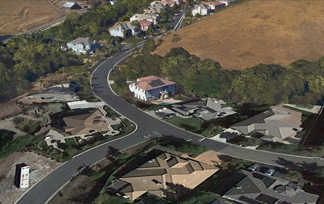
It used to be in Google Earth that everything was 2D only, and in big cities a building owner could build a 3D model of his building. That is not the 3D I am referring to in my paragraph above. Google has found a way to make entire urban neighborhoods look like they are fully three-dimensional, right down to the trees around each building. Take a look at this neighborhood I snapped a screenshot of, while I was "flying" over the neighborhood inside Google Earth. The area closest to the bottom is an area that only has the 2D data, and all of the homes appear flat. The area at the top of the photo uses Google Earth's new 3D data, and every home in the neighborhood gets projected in a full three-dimensional view.
Raise your hand if you find this just a little bit creepy.
This page is a permanent link to the reply below and its nested replies. See all post replies »
They've done nothing that innovative in their image-making unless the result is obtained by modifying the "flat-pack" images. If you had flown over that area with a film camera the image would look 3D.
@ArishMell: It would look 3D from a single position. Google Earth lets you completely rotate around the object and from different angles and altitudes while preserving the 3D shape.