@
GoldenXena google it.
Tennessee
This article is about the U.S. state. For the river, see Tennessee River. For other uses, see Tennessee (disambiguation).
Tennessee (/tɛnᵻˈsiː/) (Cherokee: ᏔᎾᏏ, translit. Tanasi) is a state located in the southeastern region of the United States. Tennessee is the 36th largest and the 16th most populous of the 50 United States. Tennessee is bordered by Kentucky and Virginia to the north, North Carolina to the east, Georgia, Alabama, and Mississippi to the south, and Arkansas and Missouri to the west. The Appalachian Mountains dominate the eastern part of the state, and the Mississippi River forms the state's western border. Nashville is the state's capital and largest city, with a population of 660,388. Tennessee's second largest city is Memphis, which has a population of 652,717.[6]
State of Tennessee
Flag of TennesseeState seal of Tennessee
FlagSeal
Nickname(s): The Volunteer State
Motto(s): Agriculture and Commerce
Map of the United States with Tennessee highlighted
Official languageEnglish
DemonymTennessean
Capital
(and largest city)Nashville [1]
Largest metroNashville Metropolitan Area
AreaRanked 36th
• Total42,143 sq mi
(109,247 km2)
• Width120 miles (195 km)
• Length440 miles (710 km)
• % water2.2
• Latitude34° 59′ N to 36° 41′ N
• Longitude81° 39′ W to 90° 19′ W
PopulationRanked 16th
• Total6,651,194 (2016 est.)[2]
• Density157.8/sq mi (60.9/km2)
Ranked 20th
• Median household income$47,330[3] (42nd)
Elevation
• Highest pointClingmans Dome[4][5]
6,643 ft (2025 m)
• Mean900 ft (270 m)
• Lowest pointMississippi River at Mississippi border[4][5]
178 ft (54 m)
Before statehoodSouthwest Territory
Admission to UnionJune 1, 1796 (16th)
GovernorBill Haslam (R)
Lieutenant GovernorRandy McNally (R)
LegislatureGeneral Assembly
• Upper houseSenate
• Lower houseHouse of Representatives
U.S. SenatorsLamar Alexander (R)
Bob Corker (R)
U.S. House delegation7 Republicans, 2 Democrats (list)
Time zones
• East TennesseeEastern: UTC -5/-4
• Middle and WestCentral: UTC -6/-5
ISO 3166US-TN
AbbreviationsTN, Tenn.
Websitewww.tennessee.gov
Tennessee state symbols
Flag of Tennessee.svg
The Flag of Tennessee
Tennesseestateseallrg.png
The Seal of Tennessee
Living insignia
AmphibianTennessee cave salamander
BirdMockingbird
Bobwhite quail
ButterflyZebra swallowtail
FishChannel catfish
Smallmouth bass
FlowerIris
Passion flower
Tennessee echinacea
InsectFirefly
Lady beetle
Honey bee
MammalTennessee Walking Horse
Raccoon
ReptileEastern box turtle
TreeTulip poplar
Eastern red cedar
Inanimate insignia
BeverageMilk
DanceSquare dance
FirearmBarrett M82
FoodTomato
FossilPterotrigonia (Scabrotrigonia) thoracica
GemstoneTennessee River pearl
MineralAgate
MottoAgriculture and Commerce
Poem"Oh Tennessee, My Tennessee" by William Lawrence
RockLimestone
SloganTennessee – America at its Best
SongNine songs
TartanTennessee State Tartan
State route marker
Tennessee state route marker
State quarter
Tennessee quarter dollar coin
Released in 2002
Lists of United States state symbols
The state of Tennessee is rooted in the Watauga Association, a 1772 frontier pact generally regarded as the first constitutional government west of the Appalachians.[7] What is now Tennessee was initially part of North Carolina, and later part of the Southwest Territory. Tennessee was admitted to the Union as the 16th state on June 1, 1796. Tennessee was the last state to leave the Union and join the Confederacy at the outbreak of the American Civil War in 1861. Occupied by Union forces from 1862, it was the first state to be readmitted to the Union at the end of the war.[8]
Tennessee furnished more soldiers for the Confederate Army than any other state besides Virginia, and more soldiers for the Union Army than the rest of the Confederacy combined.[8] Beginning during Reconstruction, it had competitive party politics, but a Democratic takeover in the late 1880s resulted in passage of disenfranchisement laws that excluded most blacks and many poor whites from voting. This sharply reduced competition in politics in the state until after passage of civil rights legislation in the mid-20th century.[9] In the 20th century, Tennessee transitioned from an agrarian economy to a more diversified economy, aided by massive federal investment in the Tennessee Valley Authority and, in the early 1940s, the city of Oak Ridge. This city was established to house the Manhattan Project's uranium enrichment facilities, helping to build the world's first atomic bomb, which was used during World War II.
Tennessee's major industries include agriculture, manufacturing, and tourism. Poultry, soybeans, and cattle are the state's primary agricultural products,[10] and major manufacturing exports include chemicals, transportation equipment, and electrical equipment.[11] The Great Smoky Mountains National Park, the nation's most visited national park, is headquartered in the eastern part of the state, and a section of the Appalachian Trail roughly follows the Tennessee-North Carolina border.[12] Other major tourist attractions include the Tennessee Aquarium in Chattanooga; Dollywood in Pigeon Forge; Ripley's Aquarium of the Smokies and Ober Gatlinburg in Gatlinburg; the Parthenon, the Country Music Hall of Fame and Museum, and Ryman Auditorium in Nashville; the Jack Daniel's Distillery in Lynchburg; Elvis Presley's Graceland residence and tomb, the Memphis Zoo, and the National Civil Rights Museum in Memphis; and Bristol Motor Speedway in Bristol.
EtymologyEdit
Monument near the old site of Tanasi in Monroe County
The earliest variant of the name that became Tennessee was recorded by Captain Juan Pardo, the Spanish explorer, when he and his men passed through an American Indian village named "Tanasqui" in 1567 while traveling inland from South Carolina. In the early 18th century, British traders encountered a Cherokee town named Tanasi (or "Tanase") in present-day Monroe County, Tennessee. The town was located on a river of the same name (now known as the Little Tennessee River), and appears on maps as early as 1725. It is not known whether this was the same town as the one encountered by Juan Pardo, although recent research suggests that Pardo's "Tanasqui" was located at the confluence of the Pigeon River and the French Broad River, near modern Newport.[13]
The meaning and origin of the word are uncertain. Some accounts suggest it is a Cherokee modification of an earlier Yuchi word. It has been said to mean "meeting place", "winding river", or "river of the great bend".[14][15] According to ethnographer James Mooney, the name "can not be analyzed" and its meaning is lost.[16]
The modern spelling, Tennessee, is attributed to James Glen, the governor of South Carolina, who used this spelling in his official correspondence during the 1750s. The spelling was popularized by the publication of Henry Timberlake's "Draught of the Cherokee Country" in 1765. In 1788, North Carolina created "Tennessee County", the third county to be established in what is now Middle Tennessee. (Tennessee County was the predecessor to current-day Montgomery County and Robertson County.) When a constitutional convention met in 1796 to organize a new state out of the Southwest Territory, it adopted "Tennessee" as the name of the state.
NicknameEdit
Tennessee is known as The Volunteer State, a nickname some claimed was earned during the War of 1812 because of the prominent role played by volunteer soldiers from Tennessee, especially during the Battle of New Orleans.[17] Other sources differ on the origin of the state nickname; according to the Columbia Encyclopedia, the name refers to volunteers for the Mexican–American War. This explanation is more likely, because President Polk's call for 2,600 nationwide volunteers at the beginning of the Mexican-American War resulted in 30,000 volunteers from Tennessee alone, largely in response to the death of Davy Crockett and appeals by former Tennessee Governor and then Texas politician, Sam Houston.[18]
GeographyEdit
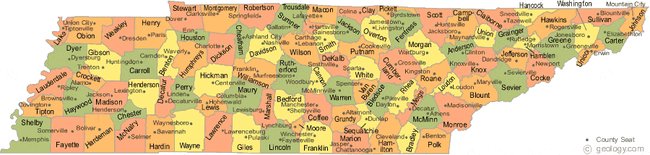
See also: List of counties in Tennessee and Geology of Tennessee
Map of Tennessee
Tennessee borders eight other states: Kentucky and Virginia to the north; North Carolina to the east; Georgia, Alabama, and Mississippi on the south; Arkansas and Missouri on the Mississippi River to the west. Tennessee ties Missouri as the state bordering the most other states. The state is trisected by the Tennessee River.
The highest point in the state is Clingmans Dome at 6,643 feet (2,025 m).[19] Clingmans Dome, which lies on Tennessee's eastern border, is the highest point on the Appalachian Trail, and is the third highest peak in the United States east of the Mississippi River. The state line between Tennessee and North Carolina crosses the summit. The state's lowest point is the Mississippi River at the Mississippi state line: 178 feet (54 m). The geographical center of the state is located in Murfreesboro.
The state of Tennessee is geographically, culturally, economically, and legally divided into three Grand Divisions: East Tennessee, Middle Tennessee, and West Tennessee. The state constitution allows no more than two justices of the five-member Tennessee Supreme Court to be from one Grand Division and a similar rule applies to certain commissions and boards.
Tennessee features six principal physiographic regions: the Blue Ridge, the Appalachian Ridge and Valley Region, the Cumberland Plateau, the Highland Rim, the Nashville Basin, and the Gulf Coastal Plain. Tennessee is home to the most caves in the United States, with over 10,000 documented caves to date.[20]
East TennesseeEdit
Main article: East Tennessee
Map of Tennessee highlighting East Tennessee
The Blue Ridge area lies on the eastern edge of Tennessee, bordering North Carolina. This region of Tennessee is characterized by the high mountains and rugged terrain of the western Blue Ridge Mountains, which are subdivided into several subranges, namely the Great Smoky Mountains, the Bald Mountains, the Unicoi Mountains, the Unaka Mountains and Roan Highlands, and the Iron Mountains.
The average elevation of the Blue Ridge area is 5,000 feet (1,500 m) above sea level. Clingmans Dome, the state's highest point, is located in this region. The Blue Ridge area was never more than sparsely populated, and today much of it is protected by the Cherokee National Forest, the Great Smoky Mountains National Park, and several federal wilderness areas and state parks.
Bald Mountains
Stretching west from the Blue Ridge for approximately 55 miles (89 km) is the Ridge and Valley region, in which numerous tributaries join to form the Tennessee River in the Tennessee Valley. This area of Tennessee is covered by fertile valleys separated by wooded ridges, such as Bays Mountain and Clinch Mountain. The western section of the Tennessee Valley, where the depressions become broader and the ridges become lower, is called the Great Valley. In this valley are numerous towns and two of the region's three urban areas, Knoxville, the third largest city in the state, and Chattanooga, the fourth largest city in the state. The third urban area, the Tri-Cities, comprising Bristol, Johnson City, and Kingsport and their environs, is located to the northeast of Knoxville.
The Cumberland Plateau rises to the west of the Tennessee Valley; this area is covered with flat-topped mountains separated by sharp valleys. The elevation of the Cumberland Plateau ranges from 1,500 to about 2,000 feet (460 to about 610 m) above sea level.
East Tennessee has several important transportation links with Middle and West Tennessee, as well as the rest of the nation and the world, including several major airports and interstates. Knoxville's McGhee Tyson Airport (TYS) and Chattanooga's Chattanooga Metropolitan Airport (CHA), as well as the Tri-Cities' Tri-Cities Regional Airport (TRI), provide air service to numerous destinations. I-24, I-81, I-40, I-75, and I-26 along with numerous state highways and other important roads, traverse the Grand Division and connect Chattanooga, Knoxville, and the Tri-Cities, along with other cities and towns such as Cleveland, Athens, and Sevierville.
Middle TennesseeEdit
Main article: Middle Tennessee
Map of Tennessee highlighting Middle Tennessee
West of the Cumberland Plateau is the Highland Rim, an elevated plain that surrounds the Nashville Basin. The northern section of the Highland Rim, known for its high tobacco production, is sometimes called the Pennyroyal Plateau; it is located primarily in Southwestern Kentucky. The Nashville Basin is characterized by rich, fertile farm country and great diversity of natural wildlife.
Middle Tennessee was a common destination of settlers crossing the Appalachians from Virginia in the late 18th century and early 19th century. An important trading route called the Natchez Trace, created and used for many generations by American Indians, connected Middle Tennessee to the lower Mississippi River town of Natchez. The route of the Natchez Trace was used as the basis for a scenic highway called the Natchez Trace Parkway.
Some of the last remaining large American chestnut trees grow in this region. They are being used to help breed blight-resistant trees.
Middle Tennessee is one of the primary state population and transportation centers along with the heart of state government. Nashville (the capital), Clarksville, and Murfreesboro are its largest cities. Fifty percent of the US population is within 600 miles (970 km) of Nashville.[21] Interstates I-24, I-40, and I-65 service the Division, meeting in Nashville.
West TennesseeEdit
Main article: West Tennessee
Map of Tennessee highlighting West Tennessee
West of the Highland Rim and Nashville Basin is the Gulf Coastal Plain, which includes the Mississippi embayment. The Gulf Coastal Plain is, in terms of area, the predominant land region in Tennessee. It is part of the large geographic land area that begins at the Gulf of Mexico and extends north into southern Illinois. In Tennessee, the Gulf Coastal Plain is divided into three sections that extend from the Tennessee River in the east to the Mississippi River in the west.
The easternmost section, about 10 miles (16 km) in width, consists of hilly land that runs along the western bank of the Tennessee River. To the west of this narrow strip of land is a wide area of rolling hills and streams that stretches all the way to the Mississippi River; this area is called the Tennessee Bottoms or bottom land. In Memphis, the Tennessee Bottoms end in steep bluffs overlooking the river. To the west of the Tennessee Bottoms is the Mississippi Alluvial Plain, less than 300 feet (91 m) above sea level. This area of lowlands, flood plains, and swamp land is sometimes referred to as the Delta region. Memphis is the economic center of West Tennessee.
Most of West Tennessee remained Indian land until the Chickasaw Cession of 1818, when the Chickasaw ceded their land between the Tennessee River and the Mississippi River. The portion of the Chickasaw Cession that lies in Kentucky is known today as the Jackson Purchase.